A new open contracting model for disaster management in Assam, India

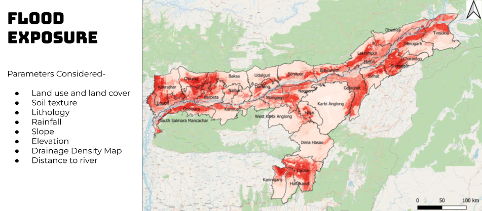
Governments often struggle to know whether the funds they invest in managing natural disasters are well spent, or how these efforts might help combat climate change and protect at-risk populations. In India, OCP and Civic Data Lab are building an intelligent data model that will help decision-makers to improve flood response and relief procurement so that the poorest and most vulnerable people in the flood-prone state of Assam are better protected from the worst effects of extreme weather events. As we embark on this new project, let’s take a look at the three datasets and other factors that make this work possible.
For more insights into the technical set up of the work, check out this blog hosted by Patrick McGovern Foundation. Their support as part of the Accelerator grant partnership is making this possible.
Floods are the most frequent natural disaster, causing widespread devastation, loss of life and livelihood, as well as property damage and critical infrastructure failures. And extreme weather events will only become more frequent and stronger as a result of climate change.
In India, floods account for more than 50% of all climate-related disasters and cause INR4.69 trillion (US$64 billion) in economic losses. In 2018 alone, 1,808 lives and an estimated INR957 billion (USD14 billion) were lost to floods. These impacts disproportionately hit the poor and most vulnerable. In India’s state of Assam, there are three to four major flooding incidents every year, affecting over 40% of the state, or 100,000 people, many with high levels of poverty, and killing hundreds of people, livestock and animals. This year’s floods are developing to be particularly damaging, affecting more than 4 million people.
As a preventative measure, investing into infrastructure can help mitigate some of the worst effects. But what is missing is the ability to track the investments made on flood relief, response, and preparedness, and to assess the extent to which this builds climate resilience or meets the most urgent humanitarian needs. Key questions related to these issues include:
- Is the money invested arriving where it’s needed most?
- Is it building long-term resilience?
- Is the relief reaching affected citizens in a timely manner?
- What is the share for short-term fixes versus long-term measures?
The lack of consolidated and accessible data, even within the government apparatus, is the crucial missing link to answer these questions. This data, which could enable more effective disaster-risk response and management, is scattered or siloed across different agencies, different systems, different scales and in different formats, making it difficult for the decision-makers and relevant stakeholders to make data-informed decisions. This often results in inefficient procurement processes and policies or ad-hoc responses that fail to adequately cater to urgent, often life-saving needs in times of emergency or provide a sustainable long-term solution where needed.
Political and policy decisions can also have a huge impact on outcomes and need to be accounted for. For example, spending may be channeled to urban areas where powerful politicians have large constituencies even though rural areas suffer from more extreme or frequent flooding. In Assam, the unpredictability of floods is heightened by the lack of transboundary cooperation e.g. due to the lack of transparency or early alerts on when or how much water will be released by dams upstream, across international borders. As a result, some regions are more vulnerable to floods than others.
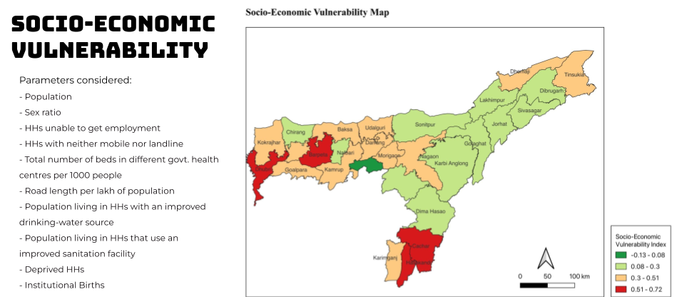
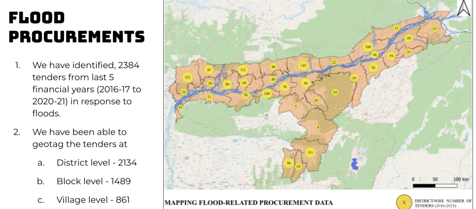
Together with CivicDataLab, an interdisciplinary research lab working to strengthen civic engagement in India, we are building a data model that combines three larger datasets which are seldom considered together. This will help us understand if flood control infrastructure is being built in areas that have the greatest need in a timely manner, and gain insights on the effectiveness of past actions and future needs for flood response and mitigation.
1. We are using satellite and meteorological data to assess exposure, severity or propensity of floods in different areas of the state.

2. We are using socio-economic data to understand the degree of vulnerability for the population residing in flood risk areas.
For these calculations, we identified and extracted indicators like population density, percentage of child and elderly population, settlement density, infrastructure in place from publicly available government sources.

3. We are using fiscal data, such as public contracts, to see how the government has been responding to floods historically and where urgent interventions are needed.
We are collecting data on expenditures under various government programs, funds and public procurement. As we were already working closely with the government of Assam on public procurement data, we received access to consolidated data including more than 30,000 tender procedures over five years. This is otherwise hidden behind captchas and not easily accessible. Analyzing this data, we have been able to identify over 2,400 large tenders (minimum value 50 Lakhs or US$65,000).

Building on these models, we are working with the Assam State Disaster Management Authority (ASDMA) and selecting district administration offices to test early results and get feedback on the ground to improve the model and dashboard.
We are going to combine these layers to model a composite index to provide analytics on how different areas of the state have performed in managing the floods with respect to their vulnerability and proneness to flooding, and where interventions are needed urgently.
Our challenge in the next few months will be to test the results of our model and iteratively work on improving it, while also ensuring the model takes into account the real-time constraints and adapts to those changes.
Here are three early insights informing the further implementation of the project:
- Our existing relationships, built over time, have been instrumental in driving progress. Our prior engagement with the government of Assam built significant goodwill and trust which in turn, incentivized officials to participate in our project activities. This also gave us credibility and helped us reach new stakeholder groups involved in or otherwise affected by floods to enrich our understanding and inform our data model, ensuring that it reflects the on ground realities and needs.
- Bringing the data together into one place is not rocket science. But it requires a lot of collaboration and work with all stakeholders to make that happen.
- A large number of emergency procurement from relief materials happen offline. We have been able to get this data for our pilot district along with interviews from the government stakeholders. Understanding their process and pain points will help us to scale up the project and analyze the outcomes.
While we are starting with one district to test the platform and collaboration models, we are planning on scaling the model to the ten districts most affected by floods out of a total of 33 districts in Assam.
This data-driven solution will help government actors make better climate adaptation decisions that can help save lives and livelihoods. It is a critical project not only for Assam, but one that serves as an example for other states in India and elsewhere. Public procurement is at the heart of effective policies. We need to make sure we use the information and put the data to work.